Winter Weather Advisory for this Weekend
The National Weather Service is forecasting a chance of rain, freezing rain, sleet, and snow for College Park, Maryland through Monday evening. There is little to no snow accumulation expected. Keep in mind with the expected heavy rainfall, potential snow, and ice, traffic delays may occur. Please plan accordingly when committing and traveling.
If the University closes due to weather conditions, the campus community will be notified through the UMD Alerts system. You can also contact the snow hotline at 301-405-SNOW (7669) or watch the local news.
For additional information, including safety tips and weather resources, check out http://www.weather.gov/alerts and http://umpdnews.umd.edu/.
Thanks, and stay safe!
--------------------------------------------------------------------------------------------------------------------------------------------------------------
Wintry Mix expected Sunday in the Washington, DC area
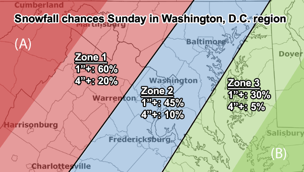
Precipitation is expected to start between the early morning and noon on Sunday in the Washington, DC area. Snow is likely before 1200 hours, then snow and sleet between 1200 to 1600 hours, then freezing rain and sleet after 1600 hours. The high will be near 34 degrees F. There is a 90% chance of precipitation, with new precipitation amounts vary depending on the weather source from between a quarter and a half an inch possible to up to an inch. The highest snow accumulation is likely to be west of DC. Sunday night there will be freezing rain and sleet before 2000 hours, then rain or freezing rain between 2000 to 0000 hours, then rain after 0000 hours, with a low of around 31 degrees F. The chance of precipitation is again 90% with new precipitation amounts between a half and three quarters of an inch possible. The rain is likely to continue on Monday, with a 60% chance of precipitation.
Source: Accuweather, NWS, Washington Post, WJLA