The National Weather Service has issued a Winter Storm Watch for the Baltimore-Washington area—meaning there is a potential for significant snow, sleet, or ice accumulation--in effect from Tuesday evening through Wednesday evening, with the possibility of snow accumulations of more than five inches and a potential for significant snowfall within the watch area. Officials forecast precipitation mixing with and changing to snow Tuesday night and continuing into Wednesday evening with temperatures in the lower and mid-30s and winds 10 to 20 MPH with gusts up to 30 MPH. Uncertainty remains with the track of the low pressure front and location of the rain-snow line which ultimately will determine snowfall totals. Potential impacts include difficult driving conditions, heavy, wet snow, and gusty winds leading to power outages.
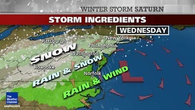
The Washington Post’s Capital Weather Gang has dubbed this storm “Snowquester;” though meteorologists continue to watch the forecast models to assess potential accumulation, there seems to be consensus that there will be snow Wednesday. The Weather Channel has dubbed this Winter Storm Saturn, and predicts significant travel impacts to include flight delays that may ripple through the East Coast through Philadelphia, New York, and Boston, even if significant storm impacts remain in the Mid-Atlantic area. Snow is likely Wednesday, with rain or snow mainly east of I-95. The snow could be heavy at times. But if the storm tracks too far south, lighter precipitation would be expected, and more rain may mix with the snow, even west of I-95. Snow and/or rain tapers off Wednesday night, with lows 30-34 (suburbs-city).
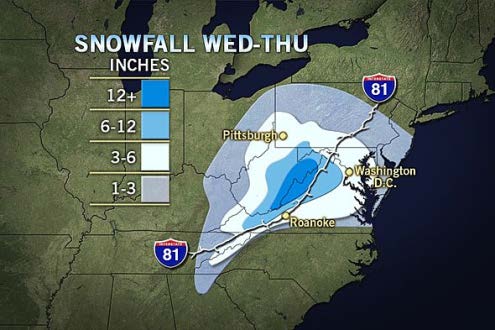
A summary of snow accumulation predictions:
- Chance of 2” or more: 70-80 percent
- Chance of 5” or more: 45-60 percent
- Chance of 10” or more: 10-30 percent
Note: The low end of the ranges apply to D.C./I-95 and points east, while the higher end of the ranges apply to areas west of D.C. and I-95 (where the accumulation potential is greater due to colder temperatures).
Source: NWS Winter Storm Watch, Washington Post, Washington Post, Weather Channel, Accuweather